RaceTac
For Racers, By Racers
Tides are good for knowing where it is safe to take your boat, but Tidal Currents are one of
those tricky things that effect your navigation, and for you racers, they are a key
advanced subject to master! Tidal Currents: First, these differ from regular stream currents as found in rivers away
from an ocean in that they are driven by ocean tidal forces. The basics of tidal currents
and tides in general are fairly simple, but the details get quite complex. I'll delve into a
bit of detail here.Tidal Currents - April 27, 2018
Basics: Most people know that the tides are caused by the gravitational attraction of the moon and, to a lesser extent, the sun. These pull on the water in the seas, tugging them upward (high tide) toward wherever they are in the orbits above the earth, and letting them sag down (low tide) again in areas of the earth on the sides they are not above. As the earth rotates during the day, the sun and moon appear over us on a roughly 24 hour cycle, and thus the tides have a daily cycle as well. This cycle is called a 'diurnal' cycle, meaning daily. As many of you know, there are two high and two low tides a day in many places. Although many can also have a double high and double low. Thus these twice daily major cycles are actually called 'semi-diurnal'. However, there are MANY other variables involved that you should be aware of! I'll get into more detail below.
Predictions: In the U.S., NOAA (National Oceanic and Atmospheric Administration) publishes predictions for tides and tidal currents. Other countries also have 'Hydrographic Offices' which do the same, such as the UK Admiralty. There are only a handful of stations which actually measure the tides and currents in real-time, mostly near heavily trafficked maritime ports and naval stations. All the rest, a few thousands of them in the U.S., are called 'stations' but are really just prediction points that have been well studied, probably by having actual sensors put in for some number of months or years, but they are not left there.
Just Predictions! These are just rough predictions. This are usually fine for general navigation, but to get the most advantage when racing, you really need local knowledge. For example, a steady high wind from some direction can make a tide, and thus current, higher or lower than usual, or even change it's timing a bit.
Rules of thumb: For a rough estimate of the timing of tides and currents, remember that the current will lag behind the tide. That is, the current will still run for a while after dead low tide or dead high tide. Also, since the main effect on tides is the moon, and the moon orbits around the earth, the moon is never in the same spot above the earth at the same time. Thus the 'lunar day' is roughly 24 hours and 50 minutes, as the moon has moved a bit and the earth's spin has to catch up to it. So the time between high tides is roughly 12 hours and 25 minutes. And the time between high and low is roughly 6 hours and 12.5 minutes. Good explanation of this is at NOAA's site HERE.
Tricky parts! Also, the 'stations' for the predictions are pretty far apart generally. Several nautical miles, or farther. Which means a lot can happen in between, and especially nearer the shore. The shape of the coast and bottom have a big effect. For example, a harbor entrance can steer a current near it as the ebb rushes out into the main body of water. Also, a point of land, neck, what have you, will steer the current, but even block it in one direction but not the other! So a point of land might steer the flood along it, but during the ebb, it might block the flow, resulting in an actual back-eddy, or reverse direction loop of current, in near the shore. A shoal area, such as one I race in, can accelerate the current as it comes up the slope of the bottom, causing a higher speed than predicted just a half nm further out. This is where buying a local sailor an 'adult beverage' and chatting about the local conditions can be a worthwhile investment!
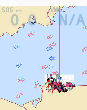
Example: Note that in the screen shot above, Long Island Sound is near the change from flood to ebb. The middle, deeper part, of the Sound is still slightly flooding in, but the edges have reversed and are starting to ebb out. In RaceTac charts, clicking on a tidal current arrow will show you a graph as below that you can scroll to your race times to help plan.
Racing Tactics: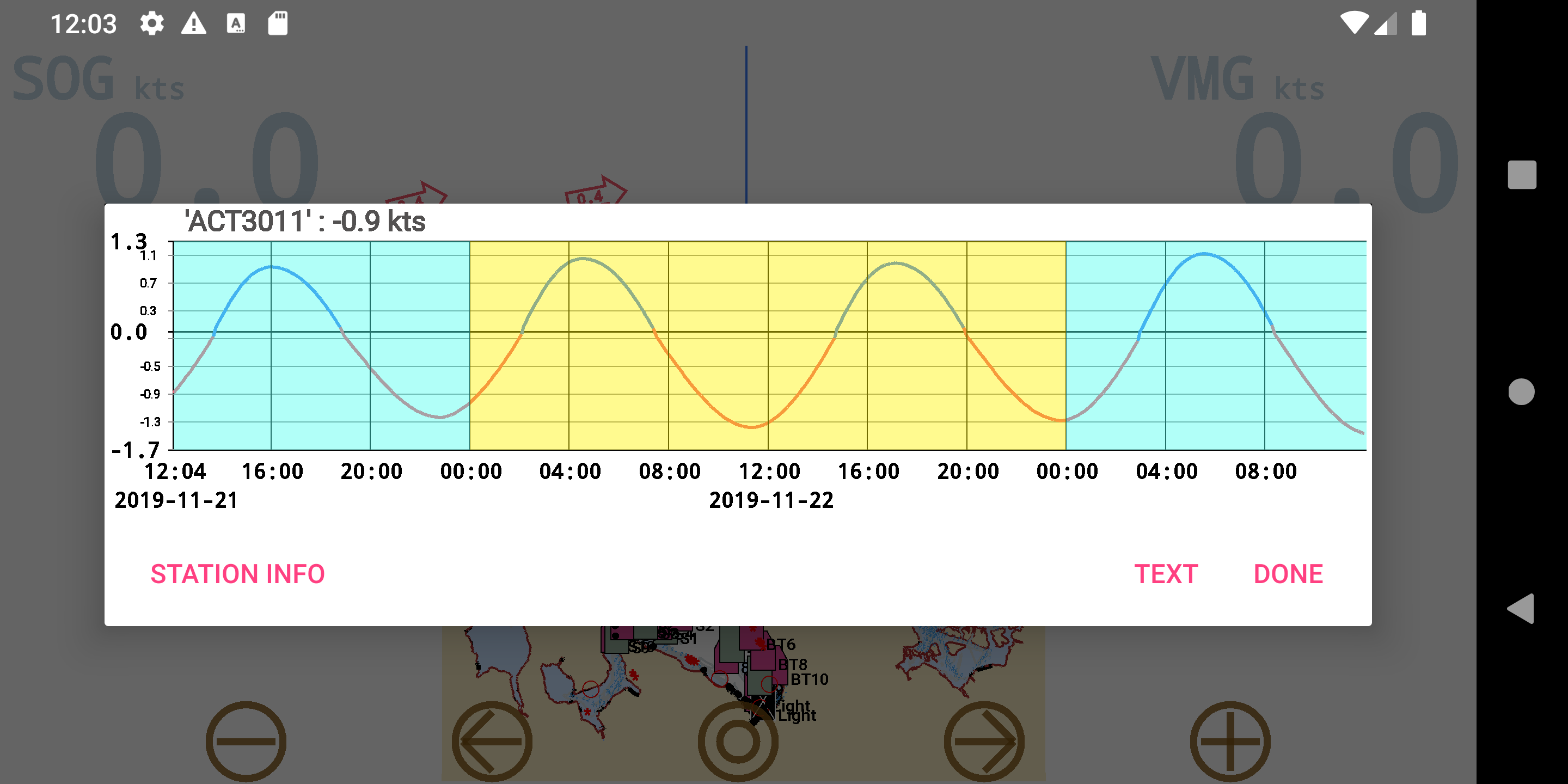 You will want to estimate the effect of the current during each leg of your race. Just as you would also estimate your
leeway (side slip). A moderate one knot current will shove you a quarter of a nautical mile over a 15 minute leg! Using a GPS track with
COG (Course over Ground) helps a lot, because it shows the actual boat direction of movement, not where you are pointing (which a
compass does). Thus the current and leeway are 'built in' to your COG heading. The other guideline is, especially in light air or when the
wind is expected to get lighter, is to steer the first tack of a leg up-current. That way, if the wind falls off, the current will be bringing you
down to the mark, as opposed to away from it! This might contradict the usual tactic of 'longest tack first'. (A good explanation of the
longest tack tactic can be found HERE. You might also want to use the current as a kicker on your first tack to boost your SOG (Speed
over Ground) and thus apparent wind, in cases where the current is stronger at the start of a leg, and will weaken later in the leg, or even
reverse if headed inshore and there is an eddy. Even downwind, you might want to jibe at some point to take advantage of the current,
or minimize it's impact if it is against you. For example, stay in close to shore and then jibe out. Yes it can get complex... play the wind?
or play the current? But figure both when planning your next leg! I have heard of a guy who dangled his anchor to catch a deeper
current when the air was dead. He used it to drift ahead of the pack. No rule against that it seems! He did not actually anchor to the
bottom, just used it for drag.
You will want to estimate the effect of the current during each leg of your race. Just as you would also estimate your
leeway (side slip). A moderate one knot current will shove you a quarter of a nautical mile over a 15 minute leg! Using a GPS track with
COG (Course over Ground) helps a lot, because it shows the actual boat direction of movement, not where you are pointing (which a
compass does). Thus the current and leeway are 'built in' to your COG heading. The other guideline is, especially in light air or when the
wind is expected to get lighter, is to steer the first tack of a leg up-current. That way, if the wind falls off, the current will be bringing you
down to the mark, as opposed to away from it! This might contradict the usual tactic of 'longest tack first'. (A good explanation of the
longest tack tactic can be found HERE. You might also want to use the current as a kicker on your first tack to boost your SOG (Speed
over Ground) and thus apparent wind, in cases where the current is stronger at the start of a leg, and will weaken later in the leg, or even
reverse if headed inshore and there is an eddy. Even downwind, you might want to jibe at some point to take advantage of the current,
or minimize it's impact if it is against you. For example, stay in close to shore and then jibe out. Yes it can get complex... play the wind?
or play the current? But figure both when planning your next leg! I have heard of a guy who dangled his anchor to catch a deeper
current when the air was dead. He used it to drift ahead of the pack. No rule against that it seems! He did not actually anchor to the
bottom, just used it for drag.
Gory details: What follows is some of the details that go into tide and current predictions. This can get a bit technical, so dive in if interested, or bail out and head for harbor if not!
Stations: NOAA reports on 4 types of current 'stations': 'Harmonic', 'Hydraulic', 'Subordinate', and 'Weak and variable'. Remember that all of these are merely prediction points. Although they may have placed measuring equipment there at one time to build up a mathematical model of the location, there likely s no real-time measuring there now. NOAA reports predictions for these in speeds, time intervals, and mean (average) ebb and flood directions.
Harmonic and Hydraulic Stations: These are very well understood locations. A Hydraulic station is called that because the primary influence is the difference between two bodies of water. And example would be 'Hell Gate' in New York City's East River. It is where Long Island Sound flows into the East River, which opens into New York Harbor and then the open Atlantic. Otherwise the data reporting is similar. NOAA has prediction data available in 6 minute, 30 minute, 60 minute, and max/slack time intervals.
Subordinate Stations: These only have Max/Slack data available. But refer to a 'Reference Station' that they are based off.
Weak and variable Stations: These do not report any prediction data. It is really just a note that there is no significant current through this area.
BINs: Station prediction data is report at one OR MORE depths. These are called 'Bins'. Shallow areas may just have a surface current reported, but deeper areas might have 2, 3, 4, or more depths. Larger ships, even subs, need to know the deeper data, but for racing, you really only need the shallowest values. Thus RaceTac uses only the shallow values.
Interpolation: Since Subordinate stations only report the max ebb, slack, and max flood times and speeds, how do you figure out what is going on in between? NOAA's web site draws a chart with a curve between the points. They use a sine curve (remember your trig?), and skew it based on the max speed of ebb and flood on either side. Many navigation programs just fit a sine curve between them. In RaceTac I used the underlying 'Reference Station' and use the 6 minute data to curve fit the Subordinate data. However in reality these are all just educated guesses! Probably good enough for racing, although do get some local info! And take into account that east wind that has been running for 24 hours!
Harmonics: So how does a Hydrographic organization like NOAA predict these values? First they start by actually measuring the data at these points. They often leave some gear there for some number of months or years. Then they use that model, and apply 'harmonics'. It turns out that, although the main influence on tides and tidal currents is the sun, moon, and rotation of the earth, there are many other little details! For example, the moon's orbit is elliptical, and so is the earth's around the sun. So the closer the moon is, the higher the tidal pull. And the orbits are tilted a bit, they are not totally flat in the plane of the solar system. And the earth is tilted as we should all know, as that causes the seasons. And that tilt is not exactly in sync with the orbital period. Plus, there is the 'slosh factor', that is, a body of water fills on the flood, then not only ebbs out, but kind of sloshes like water in a bowl. All of these effects when plotted on a chart would shows as a curve. Now some math... There was this mathematician named Fourier. A principal named after him is that any curve, even a complex one like the human heartbeat, can be expressed as the sum of regular sinusoidal curves, possibly an infinite number, but it can be done. Thus a 'Fourier Series'. Some number of them gets you accurate enough 'for government work'. Each of these curves is called a 'harmonic constituent'. A sine wave has 3 components: Amplitude (height), wavelength (distance between crests, like time between high tides), and phase (offset from some base). NOAA actually provides this data for each harmonic station if you should want to calculate these yourself! Most stations are composed of over 30 constituents! Which is enough to describe the tides and currents accurately enough to provide several years of accurate predictions. And more than accurate enough, such that weather has more of an influence than any error in the calculations.
So, just bring up those spreadsheets and get calculating! Or use NOAA's Current Prediction website, or an app like RaceTac!